
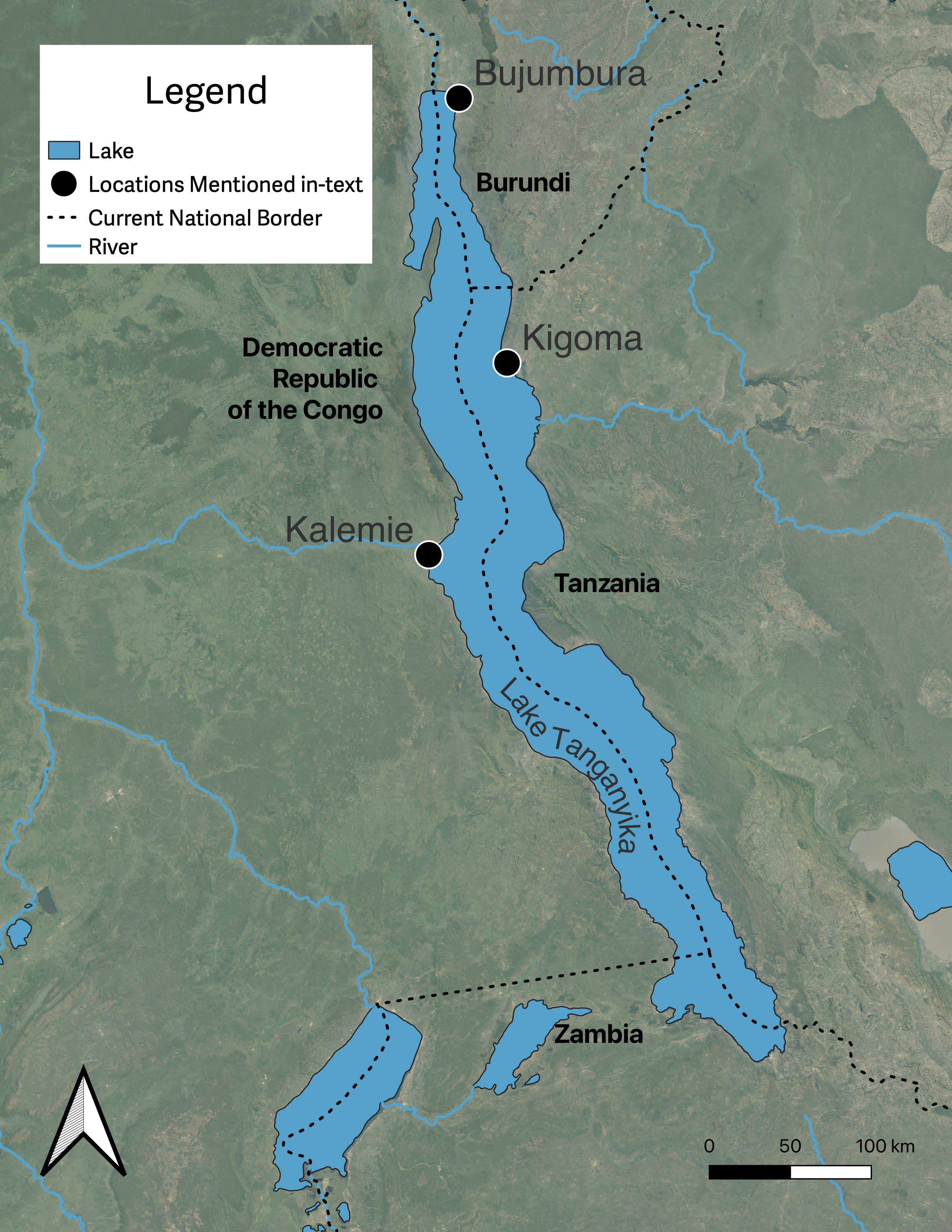
Map of Lake Tanganyika
Map of Lake Tanganyika
Map by Philip Gooding.
Base Map: Google Satellite ©2016 Google.
Based on P. Wessel and W.H.F. Smith, “A Global Self-Consistent, Hierarchical, High-Resolution Shoreline Database,” Journal of Geophysical Research Atmospheres 101, (1996): 8741–43 [https://doi.org/10.1029/96JB00104].
The copyright holder reserves, or holds for their own use, all the rights provided by copyright law, such as distribution, performance, and creation of derivative works.
The unfolding disaster on the shores of Lake Tanganyika—Africa’s deepest freshwater lake, which straddles the borders of Burundi, Tanzania, Zambia, and the Democratic Republic of the Congo (DRC)—has started to receive global attention. Since 2019, the lake has risen by around two meters, building on a steady rise of around four meters since 2006. Related flooding has been associated with internal displacement, cholera outbreaks, and infrastructural damage. According to various influential media outlets, including The Guardian, Deutsche Welle, New Scientist, and Le Monde, the key driver of these disasters is global warming. Unprecedented climate change, they imply, begets an unprecedented scale of disaster. A historical perspective, accounting for a longer-term fluctuations in Lake Tanganyika’s water level, challenges this narrative. It instead points to structural factors that have worked to increase levels of vulnerability to dramatic lake level rises.
That said, Lake Tanganyika’s two-meter rise since 2019 probably has a lot to do with global warming. Although other contributors may include tectonic activity and increased sedimentation, 2019 was a year of extreme rainfall in equatorial eastern Africa, causing all the region’s lakes to rise. This rainfall anomaly was caused by abnormal sea surface temperatures in the Indian Ocean, which are made more likely by global warming. However, although the drivers of the current rise may be unprecedented, the rises themselves are not. Lake Tanganyika has experienced several dramatic rises in the last 150 years, with comparable events occurring in the late 1870s and early 1960s: the water level rose by around four meters between 1877 and 1878 and by about six meters between 1961 and 1964. These historical patterns necessitate a reevaluation of the underlying causes of the current disaster.

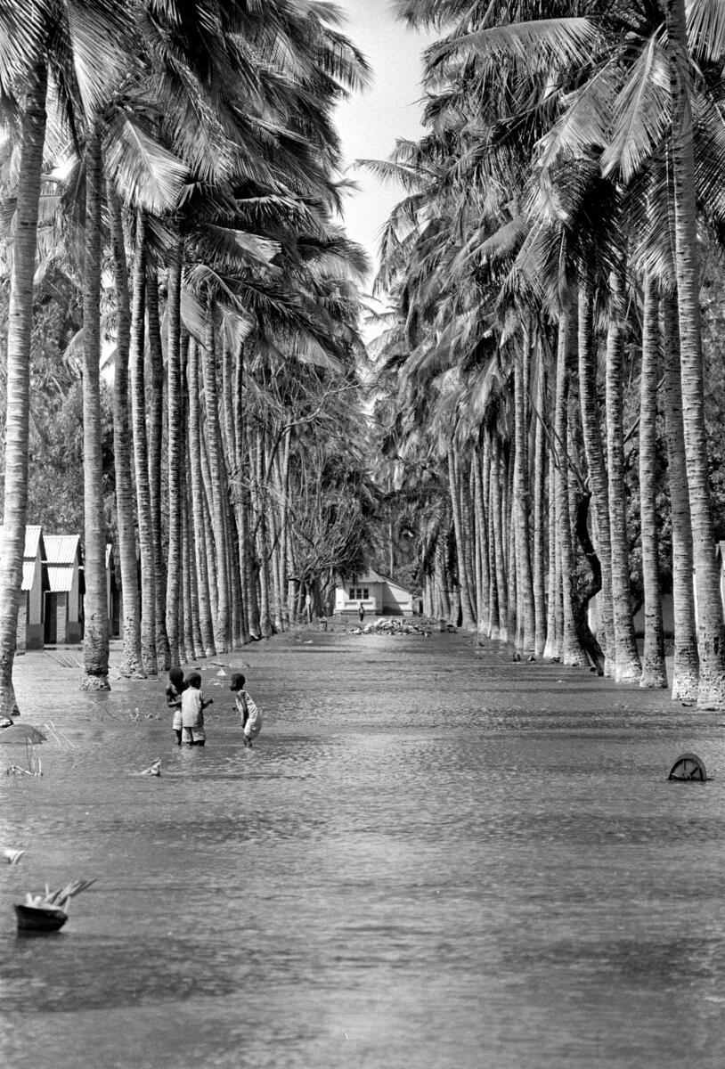
Floods in Kalemie, 1963.
Floods in Kalemie, 1963.
Unknown photographer, 1963.
© UN Photo/BZ. Click here to view source
The copyright holder reserves, or holds for their own use, all the rights provided by copyright law, such as distribution, performance, and creation of derivative works.
Importantly, the impacts of water-level rise in the late 1870s and early 1960s pale in comparison to those that have occurred since 2019. Documentary accounts of the late-1870s rise—occurring just over a decade before the establishment of European colonial rule—report on the inundation of rice paddies and the washing away of buildings in the lakeshore town of Ujiji, a current suburb of Kigoma, Tanzania. Nevertheless, these challenges did not inhibit the town’s broader historical development. Houses and markets were rebuilt further inland, and there are no reports of food insecurity following damage to rice paddies. In this context, my recent monograph argues that adapting to rising lake levels was part of a broader socio-cultural strategy centered around beliefs in spirits in the lake. Thriving in the context of changes in lake level was understood as being contingent on making short- and long-term adaptations that maintained people’s lakeshore livelihoods.
The water level rise in the early 1960s caused more distress. At this time, many African nation states were either newly independent or on the cusp of independence from European colonial powers. The emergence of regional and national capitals over the previous 70 years, such as Kalemie (in present-day DRC) and Bujumbura (in Burundi), put more people in harm’s way from rising lake waters. UN estimates suggest that around 800 homes were inundated in Kalemie by 1963, resulting in the resettlement of around 1,600 individuals. In Bujumbura, Bernard Sindayihebura’s doctoral research shows that the floods extended one to two kilometers inland, causing damage to the harbor and the nearby Quartier Asiatique and Quartier Industriel (Asiatic and Industrial Quarters). Further, around 20,000 people were evacuated from the city’s northwestern suburbs, while inundated fields, blocked roads, and damaged bridges caused the abandonment of both animal husbandry and agriculture in rural areas. By the mid-twentieth century, rapidly rising lake waters disrupted economic activities and created humanitarian challenges.

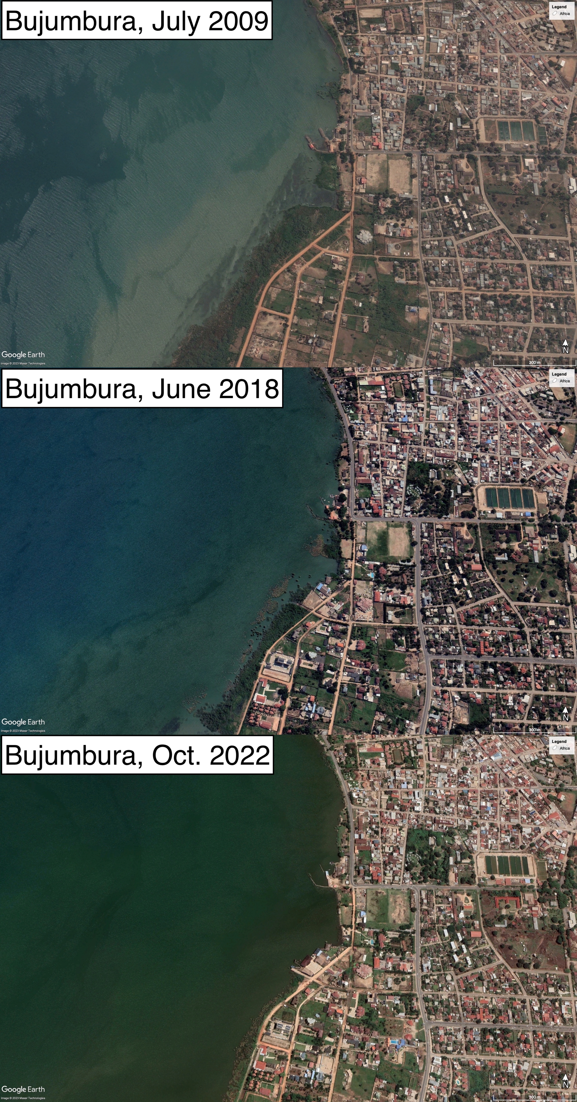
Satellite imagery of Bujumbura’s lakeshore from July 2009, June 2018, and October 2022. Note the growing proximity between lake and city from both directions, especially in the final image, which was taken just before the onset of the rainy season, during which the lake burst its banks. Infrastructure was increasingly built on areas that were vulnerable to submersion.
Satellite imagery of Bujumbura’s lakeshore from July 2009, June 2018, and October 2022. Note the growing proximity between lake and city from both directions, especially in the final image, which was taken just before the onset of the rainy season, during which the lake burst its banks. Infrastructure was increasingly built on areas that were vulnerable to submersion.
© 2023 Google Earth/Maxar Technologies
The copyright holder reserves, or holds for their own use, all the rights provided by copyright law, such as distribution, performance, and creation of derivative works.
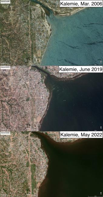
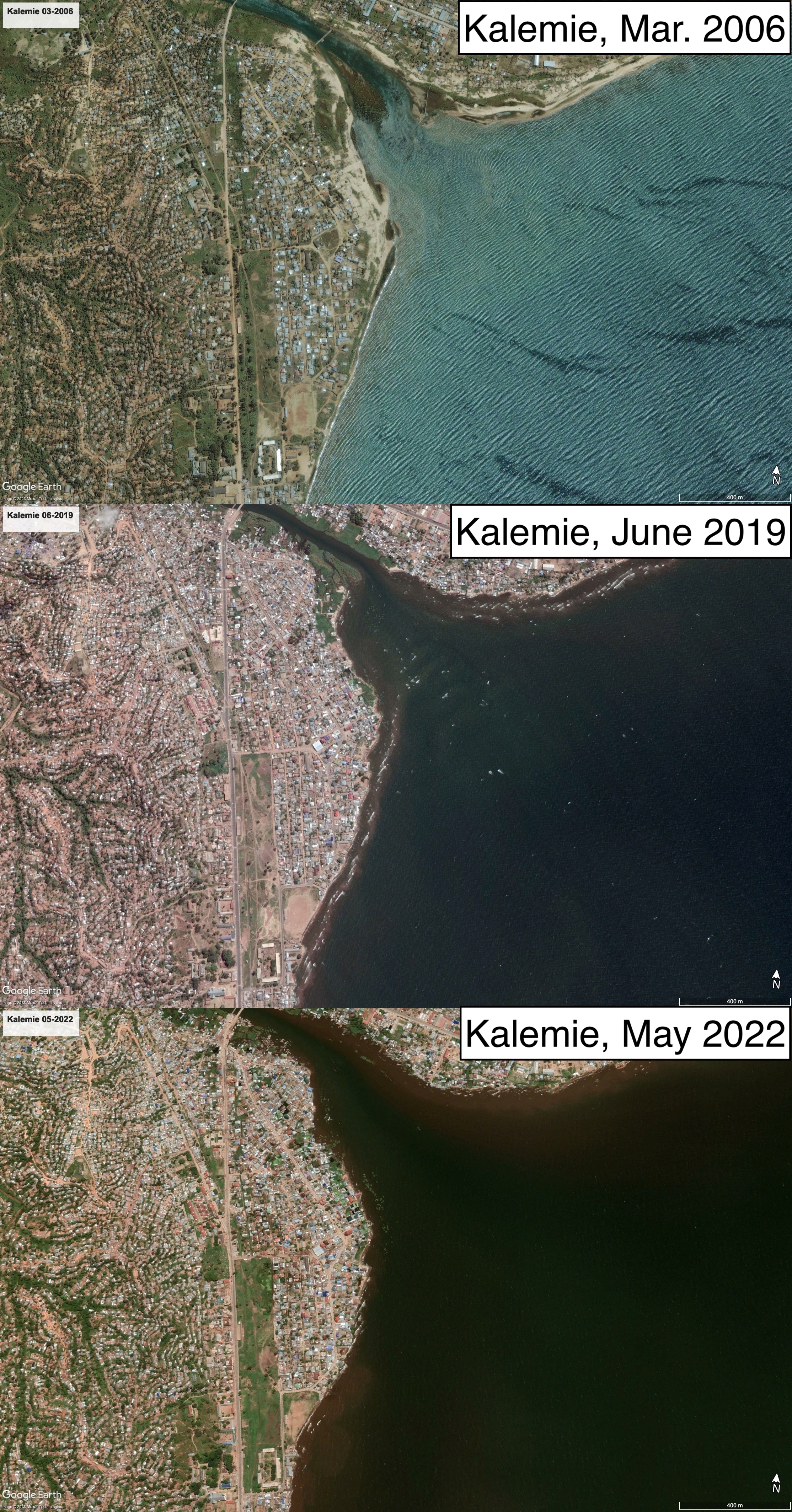
Satellite imagery of Kalemie’s lakeshore from March 2006, June 2019, and May 2022. Note the growing proximity between lake and city from both directions, especially the widening of the Lukuga River outlet from Lake Tanganyika. Infrastructure was increasingly built on areas that were vulnerable to submersion.
Satellite imagery of Kalemie’s lakeshore from March 2006, June 2019, and May 2022. Note the growing proximity between lake and city from both directions, especially the widening of the Lukuga River outlet from Lake Tanganyika. Infrastructure was increasingly built on areas that were vulnerable to submersion.
© 2023 Google Earth/Maxar Technologies
The copyright holder reserves, or holds for their own use, all the rights provided by copyright law, such as distribution, performance, and creation of derivative works.
Such challenges, however, are much more extreme in the present. Bujumbura is now a megacity of around 1.2 million people, and Kalemie’s population increased from around 15,000 to 300,000 between 1975 and 2015. According to the UN’s International Organization of Migration, around 113,000 people were internally displaced in Burundi between January 2018 and March 2022, most from flood-affected areas in Bujumbura Province. A spike in cholera cases also occurred with the onset of floods in 2019 in both Bujumbura and Kalemie. In the latter city, flooding has led to the destruction of over 100 latrines and wells, around 4,240 houses, and 112 schools. In mid-2021, around 1,100 hectares of agricultural land were under water, endangering the harvest of domestic and commercial crops. The economic and humanitarian situation in several lakeshore areas is—to an unprecedented degree—dire.
Global warming should not be regarded as the sole culprit for the current situation. Even though it may be the driver of the current lake-level rises, comparable rises during the last 150 years show that rises themselves do not necessarily beget disasters. Structural factors, including increased population density and poverty, have heightened vulnerabilities to the effects of lacustrine flooding over time. There is a need to integrate these factors, and the global and local forces that underpin them, into popular media narratives about the impacts of environmental disasters in eastern Africa. Without such integration, global warming becomes a cover for the sociopolitical decisions that turn dramatic environmental changes into economic and humanitarian disasters.
How to cite
Gooding, Philip. “Historic Lake Level Variability and Current Disasters on the Shores of Lake Tanganyika.” Environment & Society Portal, Arcadia (Autumn 2023), no. 22. Rachel Carson Center for Environment and Society. doi:10.5282/rcc/9745.
ISSN 2199-3408
Environment & Society Portal, Arcadia
 This work is licensed under a Creative Commons Attribution 4.0 International License.
2023 Philip Gooding
This refers only to the text and does not include any image rights.
Please click on an image to view its individual rights status.
- Gooding, Philip. On the Frontiers of the Indian Ocean World: A History of Lake Tanganyika, c. 1830–1890. Cambridge: Cambridge University Press, 2022.
- Sindayihebura, Bernard. “De l’Imbo au Mirwa. Dynamique de l’occupation du sol, croissance urbaine et risques naturels dans la région de Bujumbura (Burundi).” PhD diss., Université de Toulouse, 2005.
- Degroot, Dagomar, et al. “Towards a Rigorous Understanding of Societal Responses to Climate Change.” Nature 591 (2021): 539–50. doi:10.1038/s41586-021-03190-2.
- Nicholson, Sharon E. “Historical and Modern Fluctuations of Lakes Tanganyika and Rukwa and their Relationship to Rainfall Variability.” Climatic Change 41 (1999): 53–71. doi:10.1023/A:1005424619718.
- Nicholson, Sharon E. “Climate and Climatic Variability of Rainfall over Eastern Africa.” Reviews of Geophysics 55, no. 3 (2017): 590–635. doi:10.1002/2016RG000544.


